
Isochrone Maps Creation in QGIS
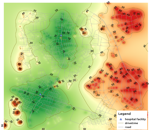
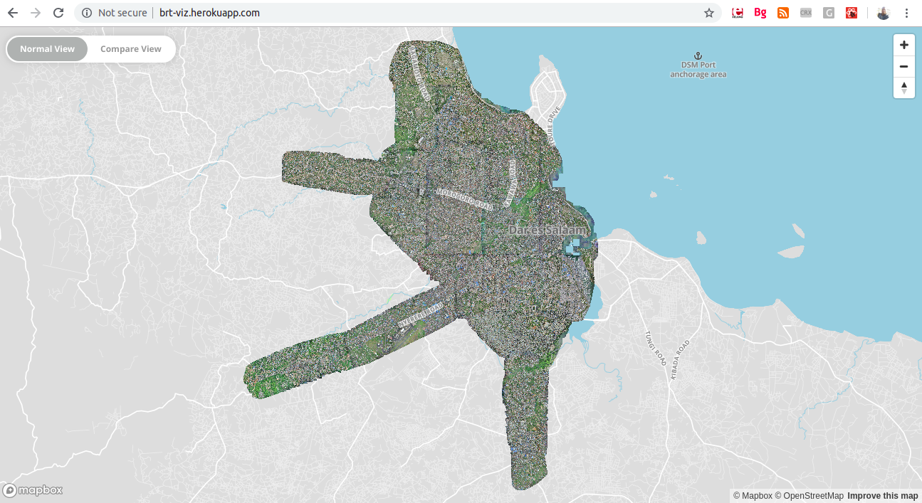
example isochrone map showing hospitals accessibility times in minutes by car
Isochrone Map
Isochrone maps are a powerful way to visualize accessibility and movement within geographic areas. Unlike traditional maps that focus on distances, isochrone maps illustrate the areas that can be reached from a specific location within a given amount of time—whether by walking, driving, cycling, or public transportation. These maps are particularly useful in urban planning, emergency response, transportation analysis and public service delivery.
For example, a city planner might use an isochrone map to evaluate how many residents can reach a health facility within 30 minutes by foot or to identify underserved neighborhoods based on commute times to the nearest school.
At the time of writing this post, there were limited options available for creating isochrone maps using open-source tools. Most services that offered isochrone generation were either commercial, limited in functionality, or required API keys with usage restrictions. Additionally, QGIS( a free desktop GIS application) did not natively support the generation of isochrones, which presented a barrier for many users interested in spatial accessibility analysis without relying on proprietary software or paid APIs.
Recognizing this gap, I created a QGIS plugin to enable users to generate isochrone maps directly within the QGIS environment. This plugin extends the functionality of QGIS by allowing users to easily define origin points, provide travel networks, and generate accessibility zones using open routing services. It simplifies a process that previously required external tools or manual steps, making it far more accessible to planners, researchers, and civic technologists who rely on free and open-source GIS software.
One of the core goals in developing the tool was to make it completely open source, so that it could be freely used, adapted, and extended by the broader GIS and open data community. The plugin is hosted publicly and available for download, with full documentation and source code accessible here.
Since its release, the plugin has received a strong reception within the QGIS community. As of August 2019, it had been downloaded over 7,000 times from the official QGIS plugin repository, highlighting the demand for accessible isochrone tools within the open-source GIS ecosystem. These numbers continue to grow as more users discover its capabilities.
The plugin is a contribution to the broader mission of opening access to geospatial analysis tools. By lowering the barrier to entry for isochrone mapping, it empowers individuals and institutions especially in resource-constrained settings to better understand, enable data based decision-making and improve accessibility in their environments.